In early February 2020—at a time when the corona virus still seemed a long way off—a video tweeted by the Global Times newspaper, which is controlled by the Chinese Communist Party, was shared on social networks. It showed startled people being reprimanded by a voice from the sky for not wearing a face mask. An elderly woman looked at the drone camera (fig. 1) in a state of total perplexity before evidently carrying out the instructions beamed from the air: “Yes, auntie, this is the drone speaking to you. You shouldn’t walk about without wearing a mask. Yes, you’d better go home and don’t forget to wash your hands. You see we’ve been telling people to stay at home but you still wander outside. Now a drone is watching you.” 1 Tweet from the Global Times, 31 January 2020, https://twitter.com/globaltimesnews/status/1223218977570078721?s=20 (all URLs in this essay were accessed on 15 September 2020 unless otherwise stated).
Judging by the comments in reply to the Global Times tweet, the video reminded Western viewers of surveillance state dystopias like George Orwell’s 1984. In China itself, on the other hand, it was dismissed as a joke, not least because of the facetious tone of the drone harangues. In fact, some of the scenes were not police images, as you might assume, but rather footage shot by a blogger who had travelled to his home village for the Spring Festival and was feeling bored because all the New Year celebrations had been cancelled in response to the lockdown. However, his humorous use of the drones, which was only ever intended for social media, was supposedly endorsed and praised by local officials. 2 Wulf Rohwedder, “Mit Drohnen gegen das Coronavirus?”, tagesschau, 4 February 2020, https://www.tagesschau.de/faktenfinder/ausland/china-drohne-corona-105.html.
Initially the video had seemed like a curiosity, but just a few weeks later camera drones equipped with loudspeakers were also used outside China to inform people about the restrictions limiting movement out of doors and the social distancing rules that were then in force—this happened, for example, in France, Great Britain, India, the USA, and Germany. 3 Alex Williams, “The Drones Were Ready for This Moment”, The New York Times, 23 May 2020, https://www.nytimes.com/2020/05/23/style/drones-coronavirus.html; “Die Polizei mahnt von oben”, taz, 10 April 2020, https://taz.de/Drohnen-Einsatz-in-der-Coronakrise/!5677868/. Agricultural drones were suddenly disinfecting entire streets, and drone delivery services also reported increased demand coming from people in self-quarantine. 4 Peter Lane-Taylor, “Could ‘Pandemic Drones’ Help Slow Coronavirus? Probably Not—But COVID-19 Is a Boom for Business”, Forbes, 25 April 2020, https://www.forbes.com/sites/petertaylor/2020/04/25/could-pandemic-drones-help-slow-coronavirus-probably-not-but-covid-19-is-a-boom-for-business/#7792d84462a4. “This is the moment when the drone industry gets to show what it can do,” The New York Times quoted an expert on drone services as saying. 5 Williams, “The Drones Were Ready for This Moment” (see n. 3). The article—whose title “The Drones Were Ready for This Moment” sounded optimistic about the future—argued that the corona crisis could give technology a boost so that “quadrocopters”, which can locate their targets autonomously, would soon become a familiar sight in our cities. 6 Ibid.
When the American Civil Liberties Union (ACLU) lodged a protest, the test flights ended up being dropped. 8 Chaim Gartenberg, “Social-Distancing Detecting ‘Pandemic Drones’ Dumped over Privacy Concerns”, The Verge, 23 April 2020, https://www.theverge.com/2020/4/23/21232592/connecticut-suburb-westport-pandemic-drones-draganfly-social-distancing. A week after the New York Times article, an incident at the Black Lives Matter protests that came in the wake of George Floyd’s death at the hands of the police also made clear what the future might hold for surveillance: a Predator-type drone, of the kind used by the CIA in Pakistan since 2004 to kill terror suspects—albeit unarmed in this case—circled above the demonstrators taking part in the 29 May protest in Minneapolis. 9 Rebecca Heilweil, “Members of Congress Want to Know More about Law Enforcement’s Surveillance of Protesters”, Vox, 10 June 2020, https://www.vox.com/recode/2020/5/29/21274828/drone-minneapolis-protests-predator-surveillance-police. As it turned out, the drone flight over Minneapolis was not an isolated incident. On 19 June 2020, The New York Times reported that aerial observation of the Black Lives Matter protests had been carried out in fourteen other cities with drones, airplanes and helicopters: Zolan Kanno-Youngs, “U.S. Watched George Floyd Protests in 15 Cities Using Aerial Surveillance”, The New York Times, 19 June 2020, https://www.nytimes.com/2020/06/19/us/politics/george-floyd-protests-surveillance.html.
MILITARY AND CIVIL TECHNOLOGY CROSSOVERS
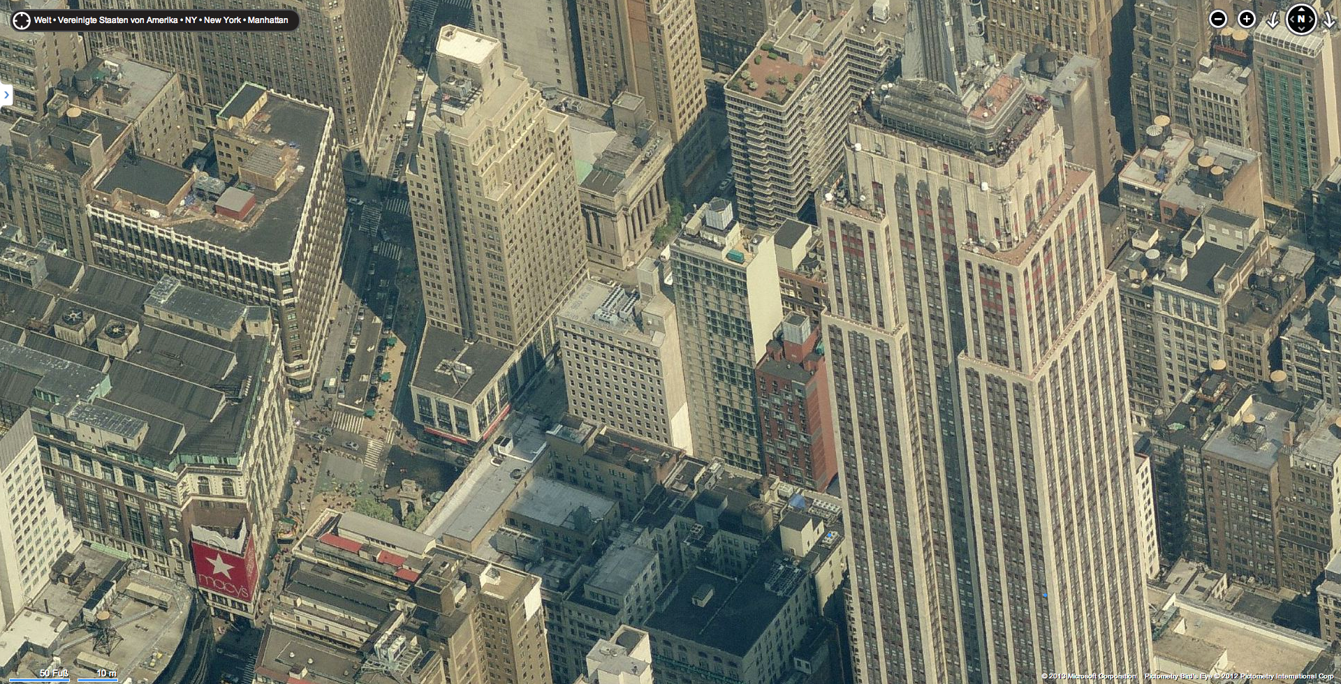
There is increasing discussion of the implications of aerial views, partly because professional camera drones have now become affordable for private individuals. This is not a new phenomenon, however: the advent of digital map services like Google Maps at the start of the millennium had prompted similar concerns about threats to privacy and internal security. In 2012, for example, New York Senator Chuck Schumer wrote an open letter expressing concerns about plans cherished by Apple and Google to produce 3D maps of US cities: “Barbequing or sunbathing in your backyard shouldn’t be a public event. People should be free from the worry of some high-tech peeping Tom technology violating one’s privacy when in your own home.” 10 "Barbequing or sunbathing in your backyard shouldn’t be a public event. People should be free from the worry of some high-tech peeping Tom technology violating one’s privacy when in your own home." - Press statement from Senator Chuck Schumer, 18 June 2012: http://www.schumer.senate.gov/Newsroom/record.cfm?id=337036 (accessed 17 September 2012). In Schumer’s view, detailed photographic map data that could be freely accessed also ran the risk of being misused in the planning of terrorist attacks (fig. 3). 11 Ibid.
The troubling image of a drone spying from the air and an act of terror perpetrated with the help of Google Maps indicate that the aerial views we have become accustomed to have links to the military. In this context, views from above make it possible to gather information about the terrain and the enemy. Advanced aerial imaging technology was often kept top secret in military circles before being made available for civil applications. For example, while Landsat, the first civil Earth-observation satellite, was not launched until 1972, the CIA had begun pursuing a secret satellite program in 1957 that would be used to photograph the Soviet Union from space with a detail accuracy of 0.61 metres from the 1960s onwards. 12 Conspiracy theorists will be pleased to note that the programme was called “Corona”. By contrast, the resolution of the first Landsat images was only 79 metres. 13 Keith C. Clarke, “Satellite Imagery and Map Revision”, in Mark Monmonier (ed.), The History of Cartography, vol. 6, Cartography in the Twentieth Century (Chicago: The University of Chicago Press, 2015), 1294–98; James B. Campbell and Joel Campbell, “Remote Sensing as a Cartographic Enterprise”, in ibid., 1298–1304. In the end it was Google Maps that first made the aerial perspective available to private individuals in the twenty-first century. Since then, such viewpoints have been a basic component of our spatial perception and orientation; if you go along with the proposition made famous by media theorist Friedrich Kittler, our daily use of aerial photographs could also be construed—based on the original source of the technology—as a “misuse of army property”. 14 Friedrich A. Kittler, Gramophone, Film, Typewriter, trans. Geoffrey Winthrop-Young and Micahel Wutz (Stanford, CA: Stanford University Press, 1999), 128.
A historically nuanced view, however, shows that the boundaries between civil and military technology are often fluid. In 2003, for example, during the Iraq War, the US news channel CNN used a new type of software called EarthViewer that made it possible to zoom in dramatically from the air on current theatres of war rather like a flight simulator (fig. 4).
fig. 4: Promotional video on the website of the company Keyhole, advertising its EarthViewer service, 9 July 2003.
At the time Keyhole Inc., the start-up company behind the app, was already giving private individuals the option of making an annual subscription to secure its services. “You [can] take that stuff generals use to plan wars and plan your mountain-biking trip” was how Keyhole’s founder and CEO John Hanke touted the app. 15 Reed Fujii, “Virtual Flights Possible with Internet Technology, Aerial Imaging”, The Record, 14 April 2003, quoted in Roger Stahl, Through the Crosshairs: War, Visual Culture, and the Weaponized Gaze (New Brunswick, NJ: Rutgers University Press, 2018), 60. In fact, In-Q-Tel, a CIA venture capital company, also began investing in Keyhole in 2003—and shortly afterwards the US military deployed the technology to help fight the ground war in Iraq. 16 Ibid., 60–61. In 2004, Google finally bought the company, and used the EarthViewer technology to launch Google Maps and Google Earth one year later. 17 Ibid., 64–66. See also Randall Stross, Planet Google: One Company’s Audicious Plan to Organize Everything We Know (New York: Free Press, 2009), 129–52.
The beginning of systematic aerial reconnaissance is generally associated with World War I. 18 See Carl Fink, “Die Entwicklung des militärischen deutschen Luftbildwesens 1911–1918 und seine militärische wie kulturelle Bedeutung”, Wehrwissenschaftliche Rundschau, no. 10 (1960): 390–99; Bernhard Siegert, “Luftwaffe Fotografie: Luftkrieg als Bildverarbeitungssystem 1911–1921”, Fotogeschichte, vol. 12, no. 45/46 (1992): 41–54; Helmut Jäger, Erkundung mit der Kamera: Die Entwicklung der Photographie zur Waffe und ihr Einsatz im 1. Weltkrieg (Munich: Venorion VKA, 2014); Manuel Köppen, “Das Luftbild im Ersten Weltkrieg: Anfänge und Auswirkungen”, in Hermann Nöhring (ed.), BilderSchlachten: 2000 Jahre Nachrichten aus dem Krieg; Technik – Medien – Kunst (Göttingen: Vandenhoeck & Ruprecht, 2009), 236–45; on the evolution of war photography in general, see Gerhard Paul, Bilder des Krieges – Krieg der Bilder (Paderborn: Schöningh, 2004). As a result, little attention has hitherto been paid to earlier approaches designed to make aerial photographs viable for military objectives or for use as maps. Even in modern-day digital maps, however, it is possible to see the principles of construction and image strategies that characterised the first prototypical designs for a photographic map in the early twentieth century. 19 On the current technologies of digital mapping, see the essays in the section “Technologies of Mapping” in Martin Dodge, Rob Kitchin and C. R. Perkins (eds.), The Map Reader: Theories of Mapping Practice and Cartographic Representation (Chichester: Wiley-Blackwell, 2011), 115–92. To help us understand today’s digital mapping techniques and the rapidly evolving technology of drones, it would thus seem important to examine the historical beginnings of aerial photography. While we now have quite precise ideas about what is possible with aerial images, at the time it was not at all clear what they were suitable for or how they could be utilised. The first conceptual approaches to aerial photography will therefore be examined in what follows as a kind of genealogy of the military gaze. What this will show is that from the outset the new perspective was also expected to enhance military capabilities.
OBSERVATION AND SURVEYING
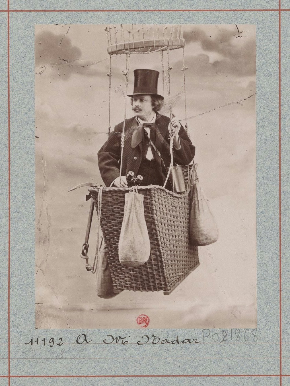
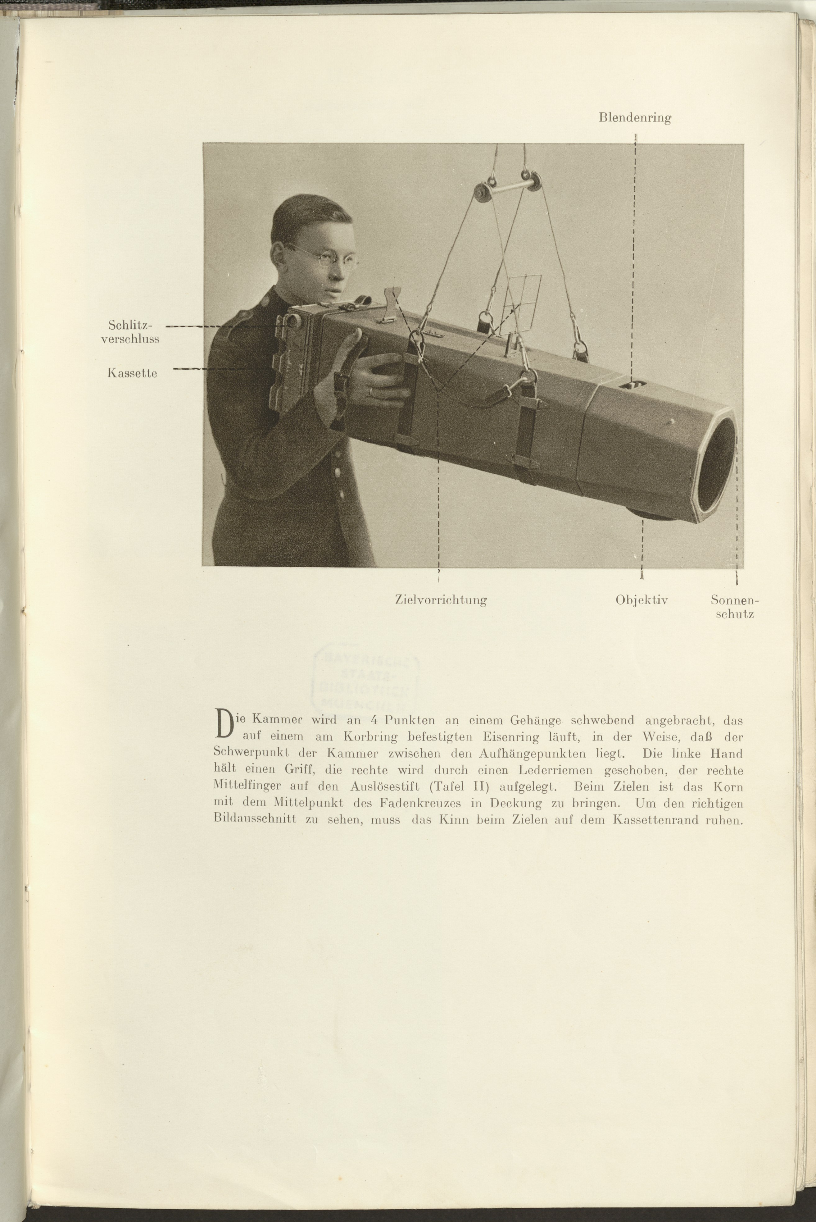
In his memoirs, Quand j’étais photographe, published around 1900, French photo-pioneer Gaspar-Félix Tournachon, better known under the pseudonym Nadar, describes how, in the autumn of 1858, he succeeded in taking the first aerial picture in the history of photography near Petit-Bicêtre—now part of the commune of Clamart. 20 Nadar, When I Was a Photographer, trans. Eduardo Cadava and Liana Theodoratou (Cambridge, MA: The MIT Press, 1978). Originally published as ibid., Quand j’étais photographe (Paris: Ernest Flammarion, c.1900). Nadar’s observations appear in more or less the same form in his earlier publication À terre et en l’air … Mémoires du Géant (Paris: E. Dentu, 1864), esp. 51–63. The illustrious Parisian photographer, who was also a ballooning enthusiast, (fig. 5) pointed out the military possibilities of aerial photography: “From a strategic point of view, we are aware of what good fortune it is for a general in a war campaign to encounter the bell tower of a village from where a Master Sergeant can make his observations. I was carrying my bell tower with me and my lens was able, successively and indefinitely, to shoot positives on glass which I would send directly from my basket to the headquarters by means of a very simple form of delivery: a small box which would slide down to the ground through the length of a rope that would bring instructions back up to me, if necessary.” 21 Nadar, When I Was a Photographer (see n. 20), 59. Furthermore, Nadar devised a scenario in which the pictures taken from his balloon would give an army commander information about the progress of a military campaign more or less in real time: “These images, immediately enlarged by projections under the eyes of the commander in chief, would present to him the entirety of his chessboard, as they would register progressively the minutest details of action and ensure for him incomparable superiority in conducting his part in the game.” 22 Ibid. Nadar’s projection of the photographic plates also spawned a new, immersive form of briefing—a procedure that would be used as an actual means of analysing aerial photographs during World War I. 23 Bildmeldung der Luftschiffer (B. d. L.), draft, Der Kommandierende General der Luftstreitkräfte, no. 2000/17 Lb., no. 62 (Charleville, 1917), Das Lesen und Erkunden der Fesselballonaufnahmen, 4; Fink, “Die Entwicklung des militärischen deutschen Luftbildwesens 1911–1918” (see n. 18), 396.
A year after taking his first successful photograph from a balloon, Nadar was asked to work on the side of the French to observe enemy movements during the Franco-Austrian War. However, while preparing for the task, every single one of the aerial photographs he took turned out a failure, which is why, by his own account, he returned the advance he had received from the French government. 24 Nadar, À terre et en l’air … Mémoires du Géant (see n. 20), 74. At first, his idea of deriving maps from vertical aerial photographs also remained no more than a theory, however suggestive his description of the process in his memoirs may have been: “The gigantic work of registering the land,” I said to myself, “with its army of engineers, surveyors, chainmen, draftsmen, accountants, had required more than a billion and more than half a century of work—to be done poorly. This year, today, I can finish it myself in thirty days—and perfectly. A good captive aerostat, a good camera, these are my only weapons.” 25 Nadar, When I Was a Photographer (see n. 20), 60. Nadar, who acknowledged in himself an “innate, absolute intractability in the face of everything that is exact science”, 26 Ibid., 71. assumed that, were “some distortion” to occur in the balloon photographs, it could be rectified “mathematically” 27 Ibid., 62.. However, Aimé Laussedat, one of the founders of what came to be called photogrammetry—a technique that made use of photography for the purposes of surveying—would explain to him the difficulties involved in mapping from the air. 28 Ibid., 71.
Nevertheless, Nadar sketched out the two fields of application that would foster the technical development of aerial photography in the twentieth century: map-making and military aerial reconnaissance. Both applications relied on the possibility of surveying the terrain shown in aerial photographs. For example, the only way to bombard enemy positions identified in the photographs was if their locations could be precisely determined and the aerial photographs compared with maps (fig. 6).
fig. 6: Artillery map based on aerial photographs, from Anleitung für den Beobachtungsoffizier im Flugzeug (A. B. O.), draft (Berlin, 1916), 10.
The fact that reconnaissance and surveying were initially pigeonholed together in the pioneering days of aerial photography is also borne out by a statement made by the geodesist Max Gasser, who saw surveying airships as “a wonderful weapon for the state concerned in time of war”. He grouped observation and surveying together with one another: “Yes, there is no need even for a refitting to be undertaken. It can be used as is, because the surveying equipment with its sophisticated cameras [...] provides the best observation pictures.” 29 Max Gasser, “Studien zu einer aerogeodätischen Landesaufnahme [Schluß]: Vortrag gehalten auf dem deutschen Geometertage zu Strassburg 1912 von Dr. Max Gasser, Dozent für Geodäsie, Darmstadt”, Zeitschrift des Vereins der Höheren Bayerischen Vermessungsbeamten, no. 17 (1913): 2–17, here: 16.
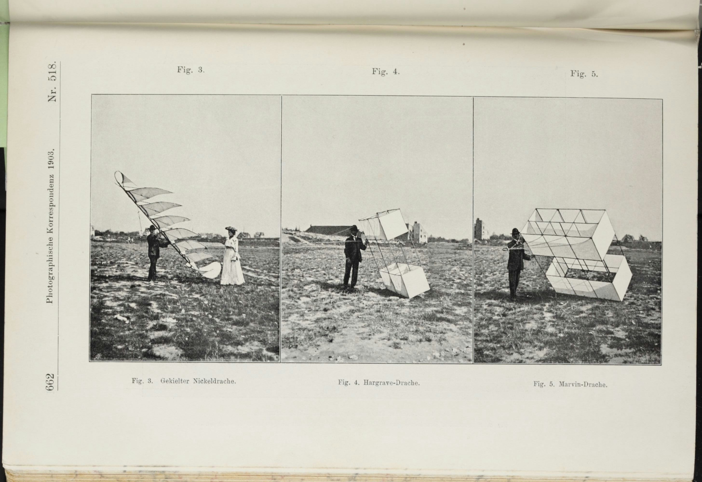
AERIAL CAMERA PROTOTYPES IN THE NINETEENTH CENTURY
Prior to the advent of airships and aircraft, aerial photographs had mainly been taken from tethered balloons, free balloons or kites—i.e. airborne devices that were fixed in place or whose direction of flight could only be influenced to a certain degree. This had encouraged ambitions to take several pictures at once from one position in order to record a larger area. 30 Willi Sander, “Über die Entwicklung der Photogrammetrie an Hand der Erfindungen unter besonderer Berücksichtigung der Doppelbild-Auswertungsgeräte”, in Otto von Gruber (ed.), Ferienkurs Photogrammetrie: Eine Sammlung von Vorträgen und Aufsätzen (Stuttgart: Verlag von Konrad Wittwer, 1930), 173–289, here: 272; Reinhard Hugershoff, Photogrammetrie und Luftbildwesen (Vienna: Verlag Julius von Springer, 1930), 148. It led, at an early stage, to the development of panoramic cameras, which could either take a succession of pictures of one area of terrain or use lenses pointed in different directions to record several images in one shot. The first device that could be termed a panoramic camera was developed in 1881 by Walter Bentley Woodbury, who had invented the Woodburytype process. 31 Stein’s and Newhall’s descriptions of the device cite 1877 as the year of manufacture, although this was the year, according to Sander, in which Woodbury submitted a patent application. Siegmund Theodor Stein, Das Licht im Dienste wissenschaftlicher Forschung: Handbuch der Anwendung des Lichtes und der Photographie in der Natur- und Heilkunde, in den graphischen Künsten und dem Baufache, im Kriegswesen und bei der Gerichtspflege, 2nd edn., vol. 2 (Halle an der Saale: Wilhelm Knapp, 1888), 226; Beaumont Newhall, Airborne Camera: The World from the Air and Outer Space (New York: Hastings House, 1969), 34; Sander, “Über die Entwicklung der Photogrammetrie” (see n. 30), 282. The device was controlled from the ground and was intended to be used in an unmanned tethered balloon. It thus anticipated the automation of aerial photography, which would ultimately lead to modern-day satellite and drone photography.
Woodbury mounted four photographic plates onto a prism-shaped drum. For each new shot, the drum could be electrically rotated by means of a cable running down the balloon’s mooring rope. The mechanised method of changing plates made it possible for several sections of an area to be photographed one after the other. 32 Newhall, Airborne Camera (see n. 31), 34–35; Eduard Doležal, “Über photographische Ballonaufnahmen und ihre Verwendung: Vortrag, gehalten den 12. Januar 1910”, Schriften des Vereins zur Verbreitung naturwissenschaftlicher Erkenntnisse Wien, vol. 50, no. 13 (1910): 335–370: 345; Sander, “Über die Entwicklung der Photogrammetrie” (see n. 30), 272. In a patent filed in 1877, Woodbury also entertained the idea of using roll film for his balloon camera, 33 Sander, “Über die Entwicklung der Photogrammetrie” (see n. 30), 282. although at that time it was still made of coated paper. 34 Newhall, Airborne Camera (see n. 31), 35. This anticipated the functional principle of the Reihenbildner reconnaissance camera—the German aircraft cameras deployed in World War I that could photograph large sections of terrain in one go by using film instead of photographic plates (fig. 7). 35 Franz Manek, “Die Luftaufnahmegeräte von Oskar Messter: Rückblick anläßlich seines 75. Geburtstags”, Luftwissen 8, no. 11 (1941): 348–51; Wolfgang Mühl-Benninghaus, “Oskar Messters Beitrag zum Ersten Weltkrieg”, in KINtop: Jahrbuch zur Erforschung des frühen Films 3 (1994): 103–15.
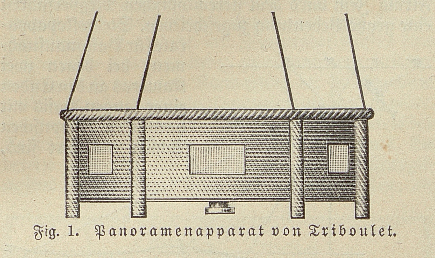
The device that Louis Triboulet produced in 1884 can be regarded as a prototype for the second kind of panorama camera, the Mehrfachkammer (or “multi-chamber” camera). This device was also designed for unmanned tethered balloons. Triboulet’s system consisted of seven cameras, with the middle camera directed vertically downwards and the other six pointing outwards (fig. 8). The devices were housed in a hexagonal box positioned in a customised wicker basket, which in turn was kept vertical by a gimbal under the balloon basket. The camera shutters were interconnected and could be released simultaneously from the ground, so that each shot captured a panoramic view of the terrain below.
fig. 8: Triboulet’s 1884 panoramic camera, from Theodor Scheimpflug, “Ballonphotographie”, in Meyers Großes Konversations-Lexikon, 6th edn., vol. 23 (Leipzig and Vienna: Bibliographisches Institut, 1912), 68–73, 69.
Back in 1882, the Académie d’aérostation météorologique, a society devoted to researching the atmosphere using balloons—of which Triboulet was a member—asked the city council in Paris for a grant of 1,000 francs to fund experiments with the camera. 36 De Bouteiller, Rapport, Présenté par M. de Bouteiller, au nom de la 5e Commission (1), sur une demande introduite par “l’Académie d’aérostation météorologique”, en vue d’obtenir une subvention de 1000 francs, destinée à l’exécution d’un levé topographique de Paris au moyen de photographies prises dans des ballons captifs: Annexe au procès-verbal de la séance du 26 juin 1882, Bibliothèque nationale de France, available online at http://gallica.bnf.fr/ark:/12148/bpt6k6427620q, 2. The academy boldly undertook to provide “a topographical plan of Paris within a short period”, 37 Ibid., 6. a “complete cadastral registry of the capital”. 38 Ibid., 3. However, the panoramic photographs were categorised by the grant applicants under the rubrics of both cartography and graphics: as vivid bird’s-eye views that complemented the topographic plan by communicating the appearance of the cityscape. Triboulet’s method reportedly admitted of “considerable savings in the realisation of a land registry map […]; it would also furnish a complete and incorruptible panoramic tableau of Paris in its current state”. 39 “Il permettrait de réaliser des économies considérables pour l’exécution d’un plan cadastral; il présenterait en outre un tableau panoramique complet et indestructible de l’état actuel de Paris.” Ibid., 6.
One significant argument that the society put forward to justify its request to the Paris city council was the military benefit of Triboulet’s invention: “We are aware of the potential interest that would attach itself to operations of this kind, carried out in the field by means of a balloon, following in the wake of the French armed forces. The results could be obtained very quickly, conveyed to headquarters and submitted to a microscopic study to ascertain the enemy’s position.” 40 “On comprend quel serait l’intérêt qui s’attacherait à des opérations de cette nature, exécutées en campagne, par un ballon, à la suite des armées françaises. Les résultats pourraient être obtenus très rapidement, portés au quartier général et sommis [sic] à une étude micrographique pour déterminer la position de l’ennemi.” Ibid., 4. The society thus adopted Nadar’s arguments almost word for word: these had also appeared in his 1864 book À terre et en l’air … Mémoires du Géant, which came out prior to the publication of his memoirs. 41 Nadar, À terre et en l’air (see n. 20), 42–43.
fig. 9: Balloon camera for military reconnaissance, from Theodor Scheimpflug, “Ballonphotographie”, in Meyers Großes Konversations-Lexikon, 6th edn., vol. 23 (Leipzig and Vienna: Bibliographisches Institut, 1912), 68–73: 69
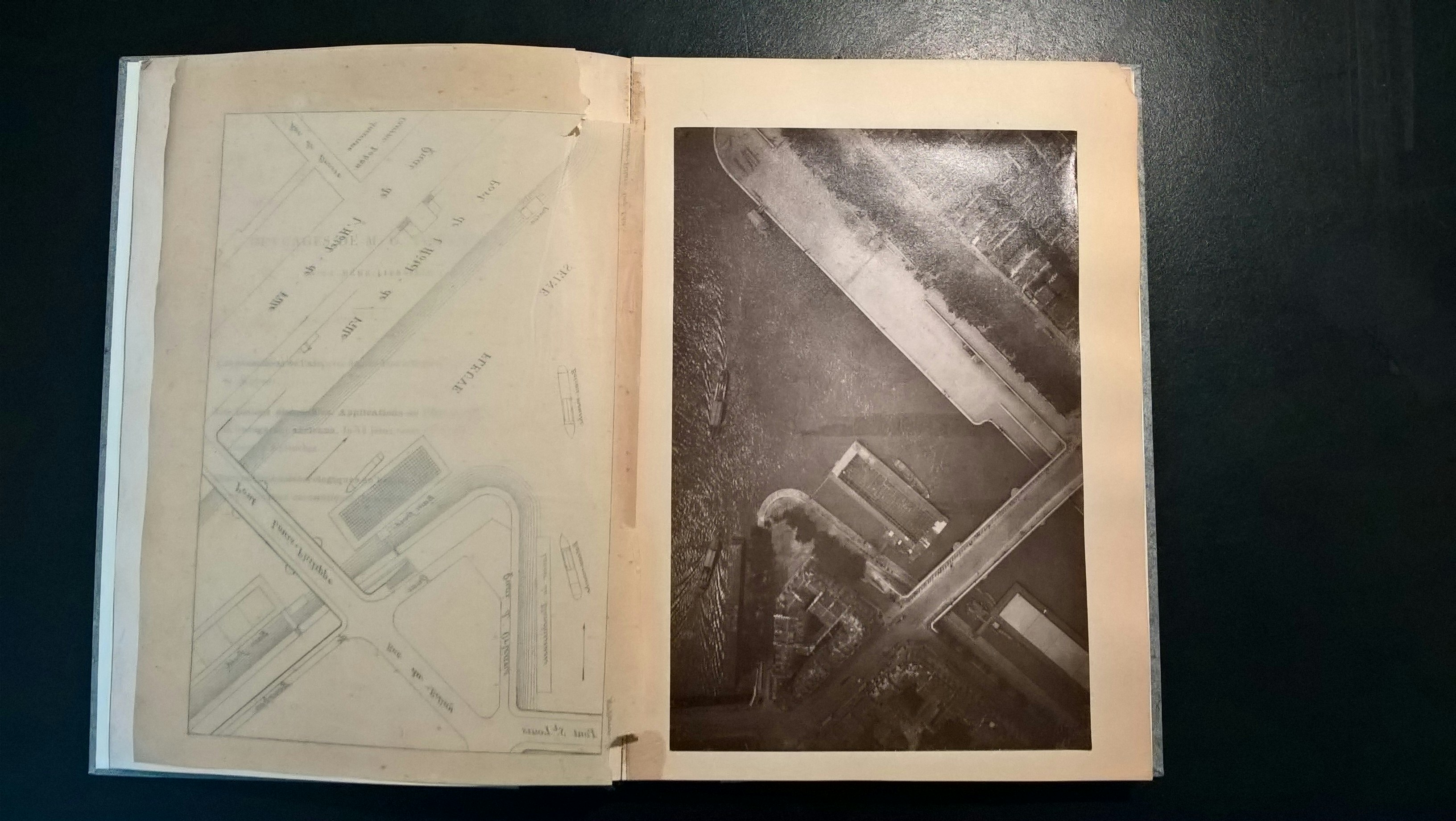
The third type of balloon camera from those decades was particularly well suited to military use: it comprised devices with very long focal lengths, which were therefore optimised for taking long shots (fig. 9). On a balloon flight over Paris on 19 June 1885, chemist and meteorologist Gaston Tissandier and photographer Jacques Ducom took with them a camera with a focal length of 56 centimetres. 42 Teodor J. Blachut, “Die Frühzeit der Photogrammetrie (bis zur Erfindung des Flugzeugs)”, in “Geschichte der Photogrammetrie”, special issue, Nachrichten aus dem Karten- und Vermessungswesen 1 (1988): 17–62, here: 30. In Tissandier’s opinion, the crispness of two or three of the photographs taken on the trip outdid anything that had previously been accomplished in aerial photography. 43 Gaston Tissandier, “La photographie en ballon”, La Nature 651, 4 July 1885, 65–68, here: 66. However, he was particularly impressed by the print of a photograph taken from a height of 605 metres above the Île Saint-Louis, “whose clarity leaves absolutely nothing to be desired”. 44 “Le cliché dont nous parlons a été fait au-dessus de Paris, à 605 mètres d’altitude; il est d’une netteté qui ne laisse absolument rien à désirer.” Ibid., 65. Tissandier’s report on the flight in the journal La Nature and his 1886 book La photographie en ballon both contained a map as an adjunct to this aerial photograph for the purposes of comparison, so that the public could be persuaded of the topographic accuracy of the photograph that had been taken (figs. 10 and 11).
fig. 10: Gaston Tissandier, Balloon photograph of Île Saint-Louis, 1885, from La Photographie en ballon (Paris: Gauthier-Villars, 1886)
fig. 11: The map appended to Tissandier’s aerial photograph, clearly demonstrating the congruity between the photo and the map.
In his report, Tissandier explained that in this particular photo, unexpected details could be discovered with the help of a magnifying glass: a rope pulley on the ship, people on the quay or chimneys on the roofs. 45 Ibid., 66; Tissandier, La photographie en ballon (Paris: Gauthier-Villars, 1886), 33. On the relationship between the magnifying glass and photography, see Jan von Brevern, “Das Instrument der Entdeckung”, in Herta Wolf (ed.), Zeigen und/oder Beweisen? Die Fotografie als Kulturtechnik und Medium des Wissens (Berlin: De Gruyter, 2016), 267–81. This kind of examination with “a magnifying reader” would become the standard way of analysing images during World War I. Because the photographs he presented were so sharp and clear, Tissandier suggested that his method of aerial photography be made available to the military as well, because “at an altitude of 600 metres, a balloon has nothing to fear from artillery fire, and the photographer in the basket can operate just as safely as in his studio”. 46 “À l’altitude de 600 mètres, un ballon n’a rien à craindre des feux de l’artillerie, et le photographe dans la nacelle peut opérer aussi sûrement que dans son atelier.” Tissandier, “La photographie en ballon” (see n. 43), 67. In this respect, however, he underestimated the future range capabilities of the guns, which also continued to develop—moreover, fighter planes equipped with machine guns could scarcely have been conceived of in 1885. In World War I, in the race between photographic and weapons technology, ever longer focal lengths were used in order to obtain images that were still detailed even from extreme heights (fig. 12).
In 1923, one aviation manual was already of the opinion that “by virtue of its mobility, speed and navigability” the advantages that the airplane offered aerial photography were “too significant for the balloon to be considered as a rival to it.” 47 Reinhard Süring and Kurt Wegener (eds.), Moedebecks Taschenbuch zum praktischen Gebrauch für Flugtechniker und Luftschiffer, 4th edn. (Berlin: Krayn, 1923), 241. Aerial reconnaissance during World War I had led to a technical leap forward. Yet experiments had also been conducted prior to 1914 with other airborne options aside from balloons, such as rockets and carrier pigeons, and especially kites. 48 Matthias Knopp, “Die Fotorakete von Alfred Maul”, in Ulf Hashagen, Oskar Blumtritt and Helmut Trischler (eds.), Circa 1903: Artefakte in der Gründungszeit des Deutschen Museums (Munich: Deutsches Museum, 2003), 450–72; Franziska Brons, “Bilder im Fluge: Julius Neubronners Brieftaubenfotografie”, Fotogeschichte 26, no. 100 (2006): 17–36. These were much cheaper to purchase and maintain than gas balloons and could be easily repaired if damaged. In addition, kites could also be flown at times when the wind was too strong for a balloon. 49 Baden Fletcher Smyth Baden-Powell, “Kite-Flying”, in Encyclopædia Britannica, 11th edn., vol. 15 (Cambridge: Cambridge University Press, 1911), 839–40: 840. While kites were used for taking measuring instruments like barometers and thermometers up to higher atmospheric strata in meteorological experiments, the military’s interest was in getting cameras or even soldiers airborne.
In May 1888 Arthur Batut, who had previously experimented, as an independent self-taught scholar, with the chronophotography of horses and composite portraits in the style of Francis Galton, 50 Arthur Batut, La photographie appliquée à la production du type d’une famille, d’une tribu ou d’une race (Paris: Gauthier-Villars, 1887). succeeded in taking the first—albeit blurred—kite photographs, showing his home town of Labruguière in the south of France. 51 Serge Negre, “Arthur Batut – Photographie – 1846–1918”, Photoresearcher, vol.2, no. 3 (1991): 20–23: 22. By reducing the shutter speed, he was able to produce convincing aerial photographs just a few months later. 52 Ibid. Based not least on Tissandier’s balloon photographs, Batut felt that there was sufficient evidence to suggest that high-quality aerial photographs were technically feasible: “But for a discovery to be truly useful, for it to yield all its fruits, it must be made universally available.” 53 “Mais pour qu’une découverte soit vraiment utile, pour qu’elle porte tous ses fruits, il faut qu’elle puisse être mise entre les mains de tous.” Arthur Batut, La photographie aérienne par cerf-volant (Paris: Gauthier-Villars, 1890), 2. His use of the kite as a comparatively inexpensive option was thus motivated by a desire to democratise the aerial perspective. Thanks to stereoscopic kite photographs, which provide a three-dimensional image of the landscape, in future “everyone will be able to allow themselves the illusion of a perilous ascent and contemplate the world from above without running the slightest risk.” 54 “Enfin, grâce aux épreuves stéréoscopiques, qu’il est aussi facile d’obtenir avec le cerf-volant que des vues ordinaires, chacun pourra se donner l’illusion d’une ascension périlleuse et contempler le monde de haut sans courir aucun risque.” Ibid., 63.
Batut’s vision of putting aerial photography in the hands of the masses would not be realised until the twenty-first century with the advent of drone photography. As early as 1890, however, he conceived of a variety of possible applications for an unmanned flying object equipped with a camera, ranging from land surveying and the exploration of inaccessible areas to agriculture. As the technology weighed very little, Batut also imagined that any military unit could carry with it the equipment required for kite photography and use it for reconnaissance purposes. 55 Ibid., 62–64.
According to Theodor Scheimpflug, a former captain in the Austro-Hungarian Armed Forces, who had himself experimented with kite photography in the early part of the twentieth century (fig. 13), the “military efforts to make kites serviceable for the purposes of reconnaissance […] naturally led to attempts to lift people with kites.” 56 Theodor Scheimpflug, “Über die Verwendung von Drachen zu praktischen Zwecken”, in Hermann Hoernes (ed.), Buch des Fluges, vol. 1 (Vienna: Verlag Georg Szelinski, 1911), 598–603, here: 600. On the first attempts to use kites put people in the air, see Joseph Lecornu, Les cerfs-volants (Paris: Librarie Nony & Cie., 1902), 123–40. In 1904, Scheimpflug also published detailed calculations to show how a person could be lifted aloft: “The man sits inside the kite in a sprung basket, meaning that he is not at too great a risk even in the event of an accident, since kites almost never fall so heavily that they break apart completely.” 57 See the sections “Die beim Heben von Menschen mit Drachen in Betracht kommenden Kraft- und Größenverhältnisse” and “Die Handhabung der Drachen” from Scheimpflug’s essay “Über Drachenverwendung zur See”, Mitteilungen aus dem Gebiet des Seewesens 32, nos. 4 and 5 (1904): 4:305–17 and 5:396–431: 407–429, esp. 423. However, greater attention was paid to the kite experiments conducted by British officer Baden Fletcher Smyth Baden-Powell, a brother of Robert Baden-Powell, who would go on to found the Scout movement, and the US American Samuel Franklin Cody. 58 Baden Fletcher Smyth Baden-Powell, “Kites: Their Theory and Practice”, Aeronautical Journal, vol. 2, no. 6 (1898), 33–45; Baden-Powell, “War Kites”, Aeronautical Journal, vol. 3, no. 9 (1899), 1–6; Baden-Powell, “Kite-Flying” (see n. 49), 840.
Cody, who took on the surname of his idol Buffalo Bill—William Frederick Cody—had come to England in 1888 with a Wild West show. 59 G. A. Broomfield, “S. F. Cody: A Personal Reminiscence”, Flight, vol. 73, no. 2573, 16 May 1958, 690–91, here: 690. Broomfield was Cody’s mechanic and his first biographer—with the book Pioneer of the Air (Aldershot: Gale & Polden, 1953). Despite being an eye witness to events, his account should be read critically: he antedated Cody’s test flights by several months, so that he would have a prior claim to having piloted the first powered flight in England, before Alliott Verdon Roe. See, for example, Charles H. Gibbs-Smith, “S. F. Cody: An Historian’s Comments”, Flight, vol. 73, no. 2574, 23 May 1958, 699. While Baden-Powell carried out his experiments with manned kites in the 1890s as an army officer, Cody, who was the spitting image of Buffalo Bill and was regarded as an eccentric showman, made a concerted attempt to sell his kite construction to the military. Initially repulsed, he gave a demonstration of his system to the Royal Navy in Portsmouth in 1903. Suspended beneath the kite, he had himself pulled above the fleet at a height of 240 metres. He took pictures from the air and passed on information about the outcomes of artillery fire. 60 Broomfield, “S. F. Cody: A Personal Reminiscence” (see n. 59), 690. After another demonstration the following year, the British armed forces did, in fact, agree to work together with the maverick inventor (fig. 14). His “Cody War Kite” system, which involved having a soldier go up as an observer, was part of the military armoury until shortly before the start of World War I (fig. 15). 61 “Kiting”, Royal Airforce Museum, https://www.rafmuseum.org.uk/research/online-exhibitions/rfc_centenary/british-military-aviation-1862-1912/Kiting.aspx.
However, all earlier experiments with kite photography were outdone by George R. Lawrence, who used up to seventeen Conyne kites strung together in series to lift his heavy, large-format plate cameras into the air. The enormous pull exerted by a kite “team” like this meant that the winch had to be anchored to the ground and operated by two people. Lawrence’s panoramic camera hung below the last kite in the series and to keep it stable in the wind, it was counterbalanced by three spider-leg rods with lead weights attached to their ends (fig. 16). The photographs were triggered from the ground via an electrical cable integrated into the kite line. A small parachute was dropped to indicate that the picture was complete. 62 Simon Baker, “San Francisco in Ruins: The 1906 Aerial Photographs of George R. Lawrence”, Landscape, vol. 30, no. 2 (1989), available online at http://robroy.dyndns.info/lawrence/landscape.html; Janice Petterchak, “Photography Genius: George R. Lawrence & ‘The Hitherto Impossible’”, Journal of the Illinois State Historical Society, vol. 95, no. 2 (2002), 132–147: 139–143.
In 1905, at the request of President Roosevelt, Lawrence was invited by the US Army and Navy to give a demonstration of his kite photography. 63 Ibid., 141. In 1906, he photographed the ruins of San Francisco a few weeks after the city had been devastated by the great earthquake and subsequent fires (fig. 17). In order to capture the image, which was taken from a height of 600 meters, he used a 22-kilogram panoramic camera with a film plate of about 1.2 metres in width. 64 Baker, “San Francisco in Ruins” (see n. 62), n.p. Based on the spectacular photograph, he was invited to take part in another exercise in 1907 to test the suitability of his “Captive Airship” system for military purposes. 65 Petterchak, “Photography Genius” (see n. 62), 143.
THE FIRST PHOTOGRAPHIC MAPS AS THE START OF REMOTE SENSING
In the late 1850s, the concept of photogrammetry was developed and work began on a process that could derive the lengths of objects from photographs by inverting the laws of projection, for example to produce topographical maps or architectural drawings. 66 On the historical background of terrestrial photogrammetry, see Herta Wolf, “Das Denkmälerarchiv Fotografie”, in Paradigma Fotografie: Fotokritik am Ende des fotografischen Zeitalters, vol. 1 (Frankfurt am Main: Suhrkamp, 2002), 349–75; Jan von Brevern and Katja Müller-Helle, “Die Vermessung der äußeren Wirklichkeit”, IFKnow 1 (2011): 8–9; Jan von Brevern, Blicke von Nirgendwo: Geologie in Bildern bei Ruskin, Viollet-le-Duc und Civiale (Munich: Fink, 2012), 52–60, and “Fototopografia: The ‘Futures Past’ of Surveying”, in Intermédialités: Histoire et théorie des arts, des lettres et des techniques / Intermediality: History and Theory of the Arts, Literature and Technologies, no. 17 (2011): 53–67: 55. The complexity involved in analysing terrestrial mapping images posed a problem, so that it took decades before sufficiently accurate and practicable methods became available. 67 On the early history of the technology of photogrammetry, see Blachut, “Die Frühzeit der Photogrammetrie” (see n. 42); Sander, “Über die Entwicklung der Photogrammetrie” (see n. 30). As a result, many geodesists were sceptical that aerial photographs might one day be used to obtain topographic maps: the images were inevitably lopsided and it was impossible to precisely reconstruct the location at which they were recorded. 68 See, for example, Max Eckert, Die Kartenwissenschaft: Forschungen und Grundlagen zu einer Kartographie als Wissenschaft, vol. 1 (Berlin: Walter de Gruyter, 1921), 273–80.
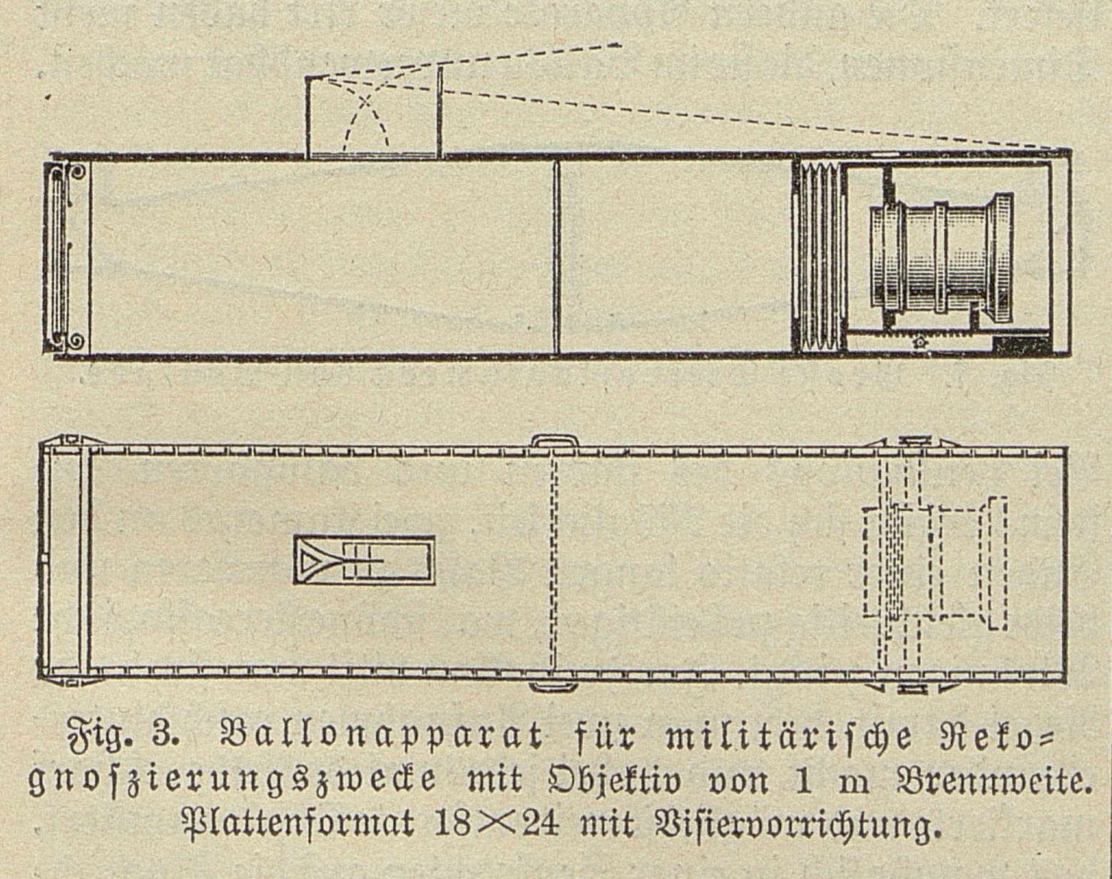
In the decade leading up to World War I, experiments in what was called aerophotogrammetry were still being carried out in a number of different countries: for example, by Theodor Scheimpflug in Austria-Hungary, Sebastian Finsterwalder and Max Gasser in Germany, Jacques-Théodore Saconney in France, Richard Thiele in Russia and Éduard Deville in Canada (fig. 18). These experiments were based on an idea that sounded straightforward: as an aerial photograph taken vertically already resembles a map, should it not be possible to transform it into a true-to-scale rendering of the terrain by correcting the distortions in it (fig. 19)? Large areas could then be mapped very quickly, “quite literally ‘in flight’”. 69 Egon Dewidels, “Die Aufnahme von Neuland durch Aerophotogrammetrie”, Allgemeine Ingenieur-Zeitung: Organ des Allg. Ingenieur-Vereines in Wien, no. 9/10 (1913): 61–67: 61. This premise not only spawned methods for generating information about the earth’s surface that are now classed as remote sensing but also gave rise to a new type of image: the photographic map.
fig. 18: “Topography: Then – Now”, from Max Gasser, “Die photogrammetrische Messkunst in der Aeronautik”, Deutsche Luftfahrer-Zeitschrift, vol.16, no. 19 (1912), 467–472: 469
Prior to World War I, Scheimpflug’s “Photokarte” was the best-known photographic method of map-making. 70 For a more detailed account of Scheimpflug’s methods, see Michael Kempf, “Zwischen Bildrauschen und Orientierungswissen: Theodor Scheimpflugs frühe Versuche mit fotografischen Karten”, in Herta Wolf (ed.), Zeigen und/oder Beweisen? Die Fotografie als Kulturtechnik und Medium des Wissens (Berlin: De Gruyter, 2016), 219–43. Before resigning his commission, Scheimpflug had been stationed at the Austro-Hungarian Military Geographic Institute in Vienna. Thereafter, he financed his experiments from his own resources and, from 1900 on, developed a range of equipment for taking and analysing aerial photographs. 71 For Scheimpflug’s (albeit affirmatory) biography, see Eduard Doležal and Karl Lego, “Theodor Scheimpflugs Leben und Wirken”, in Theodor Scheimpflug: Festschrift zum 150jährigen Bestand des staatlichen Vermessungswesens in Österreich, ed. Bundesamt für Eich- und Vermessungswesen, Österreichischen Verein für Vermessungswesen, Österreichische Gesellschaft für Photogrammetrie (Vienna: Österr. Verein für Vermessungswesen, 1956), 5–15. In order to be able to take photographs of as large an area as possible, he built a panoramic device with seven cameras grouped in a ring around a central lens, which could be activated simultaneously from the balloon basket. The lens in the middle pointed vertically downwards, while the cameras on the surrounding ring were inclined at a 45° angle (fig. 20).
fig. 20: “Scheimpflug’s eight-part aerocamera: During exposure”, from Gustav Kammerer, “Th. Scheimpflugs Landvermessung aus der Luft”, Internationales Archiv für Photogrammetrie, vol. 3, no. 3 (December 1912), 196–226: 202
The construction had its origins in Triboulet’s multi-lens panoramic camera from the 1880s. The higher Scheimpflug’s balloon rose, the larger the area recorded by his device: at an altitude of as little as 225 metres, the plates could record 100 hectares; at an altitude of 4,500 metres, 40,000 hectares. 72 Gustav Kammerer, “Th. Scheimpflugs Landvermessung aus der Luft”, Internationales Archiv für Photogrammetrie, vol.3, no. 3 (December 1912), 196–226: 208. However, in order to achieve this kind of coverage, the photographs—which were taken simultaneously by cameras pointing in different directions—had to be corrected and assembled into a complete image (figs. 21 and 22).
fig. 21: “Fig. 5: Original photographs with T. Scheimpflug’s eightfold panoramic device”, from Gustav Kammerer, “Th. Scheimpflugs Landvermessung aus der Luft”, Internationales Archiv für Photogrammetrie, vol. 3, no. 3 (December 1912), 196–226, plate I.
fig. 22: “Fig. 6: The original image in fig. 5 rephotographed to create a complete panorama”, Internationales Archiv für Photogrammetrie, vol. 3, no. 3 (December 1912), 196–226, plate II
Scheimpflug experimented with different cartographic imaging based on aerial photographs. Even at the time, the proposals he came up were able to mimic the kind of photorealistic views that we know today from services like Google Maps. However, a cartographic reworking of the aerial image material could also raise the issue of the difference between map, image and diagram. The complex editing involved meant that in many cases it was no longer obvious that a map of this kind was based on an aerial photograph (fig. 23). Scheimpflug’s subsequent concept of the “Photokarte” thus no longer set out to create a photographic impression of reality but can be compared, instead, with the way data is handled in a modern geographic information system (GIS). The idea was to use printing plates of different colours to augment the photographic base map with information such as contour lines, borders, transport routes or labelling (fig. 24). 73 Ibid., 218. Recombining the printing plates as information media would have given rise to completely different maps, analogous to the insertion and superimposition of different layers of information of the kind we are familiar with today in digital maps. Adding in more printing plates with additional spatial data would have made it possible to produce new topographic knowledge on a continuous basis using generated map images, along the lines of a GIS. 74 Chromolithography and photolithography can be seen as precursors of today’s geographic information systems inasmuch as these processes break up the self-contained map image for printing and transfer the content to thematically separate printing plates. The idea behind doing this was to print different types of information in different colours, which was only possible using separate plates. One could argue that this anticipated the concept of “layers” in GIS—the storage of data in layers of equal value, the superimposition of which makes it possible to generate a cartographic image of the kind desired.
fig. 23: A “Photokarte” in a simple configuration, c. 1912, from Gustav Kammerer, “Th. Scheimpflugs Landvermessung aus der Luft”, Internationales Archiv für Photogrammetrie, vol. 3, no. 3 (December 1912), 196–226, plate IV.
Scheimpflug’s method was still more or less untested, and he put any reservations about it down to the fact that surveyors saw aerial photogrammetry as a threat to their professional survival. As a result, he soon went over to promoting aerial photography as a means of surveying the colonies. 75 Theodor Scheimpflug, “Die technischen und wirtschaftlichen Chancen einer ausgedehnten Kolonial-Vermessung”, in Richard Wachsmuth (ed.), Wissenschaftliche Vorträge gehalten auf der Ersten Internationalen Luftschiffahrts-Ausstellung (ILA) zu Frankfurt A/M. 1909 (Berlin: Verlag von Julius Springer, 1910), 177–202: 180. Since his aerophotogrammetry was intended to further the development and control of territories to which a claim had been staked and streamline their economic exploitation, it should also be seen as an instrument of power in the colonial context. 76 “Maps are both complex and effective instruments of power. They open up a space of possibility by offering the people reading them scope for action, thus inviting them to change reality. At the same time, the power to confer a name on the areas that have been identified emanates from the very surface of the paper, and the consequences of this often come to shape reality. Maps are thus characterised by a dual form of pragmatism: they furnish the possibility of action and are themselves expressions of the politics of power.” David Gugerli and Daniel Speich, Topografien der Nation: Politik, kartografische Ordnung und Landschaft im 19. Jahrhundert (Zürich: Chronos Verlag, 2002), 75. It was thus considered an advantage that the native population in the colonies would be essentially unable to defend themselves against aerial surveys, as one of Scheimpflug’s supporters explained: “Neither the savagery of cannibals nor the extreme impassability of the terrain can prevent the topographic recording of uncharted territory.” 77 Dewidels, “Die Aufnahme von Neuland durch Aerophotogrammetrie” (see n. 69), 61. Yet although various proposals were put forward—such as the photographic mapping of New Guinea—no major aerophotogrammetric topographic surveys were undertaken abroad until the 1920s. 78 Detlef Siegfried, “Kartierung der Welt: Das Luftbild in der Weimarer Republik”, in Adam Paulsen and Anna Sandberg (eds.), Natur und Moderne um 1900: Räume – Repräsentationen – Medien (Bielefeld: transcript, 2013), 285–303, here: 297–99.
When Scheimpflug died unexpectedly in 1911, his long-time colleague Gustav Kammerer continued his experiments. One such venture saw Kammerer providing support to the Dresden-based Ernemann company in their development of a device for correcting distortion in military aerial photographs. 79 Josef Krames, “Scheimpflugs Landesvermessung aus der Luft”, in Theodor Scheimpflug (see n. 71), 63–79:75. Prior to this, in 1910, Major General Sir John Edward Capper, who had been tasked with building up the Royal Air Force, ordered “military reconnaissance equipment (consisting of an aerocamera adjusted for photogrammetry and a photographic perspectograph)”. 80 Gustav Kammerer, “Flugwesen in den Kolonien”, Deutsche Kolonialzeitung 29, no. 51, 21 December 1912, 879–80, here: 879. See also John Edward Capper, “Travelling in the Air”, The Royal Engineer Journal 12, no. 3 (1910): 219–24. Capper reports here on Scheimpflug’s invention for an English readership. Kammerer explained its military benefits as follows: “Such equipment is capable of converting, within a few minutes and without any artificial light source, oblique photographs of the enemy camp taken from the heights above one’s own camp into horizontal bird’s-eye views; providing a direct reading of the distances of enemy troops or ships.” 81 Kammerer, “Th. Scheimpflugs Landesvermessung aus der Luft” (see n. 72), 224.
A tragic accident spelled the end of Scheimpflug’s aerophotogrammetry—just at the point when the Austro-Hungarian War Ministry was becoming increasingly interested in the procedure. 82 Kammerer, “Flugwesen in den Kolonien” (see n. 80), 879. On 20 June 1914 nine people died in the “balloon disaster in Fischamend”, 83 “Ballonkatastrophe in Fischamend: Zusammenstoß zwischen einem Körting-Ballon und einem Aeroplan; Sämtliche neun Insassen getötet”, Neue Freie Presse, no.17894, 20 June 1914, evening edition, 1–2. a sensational air crash that also made headlines in American newspapers. 84 For example, “Nine perish when ’plane hits airship”, New York Tribune, no. 24689, 21 June 1914, 1. An unsuccessful military manoeuvre resulted in a collision between a plane and an airship. The Körting balloon, which had only been made available to the Austro-Hungarian Military Geographic Institute at the beginning of the month to test the surveying technology, was involved in the crash. 85 “Das Scheimpflug-Kammersche Verfahren”, Neue Freie Presse, no. 17894, 20 June 1914, evening edition, 3. When the airship exploded, Scheimpflug’s successor Gustav Kammerer was on board.
NOW WE ARE ALL SPIES
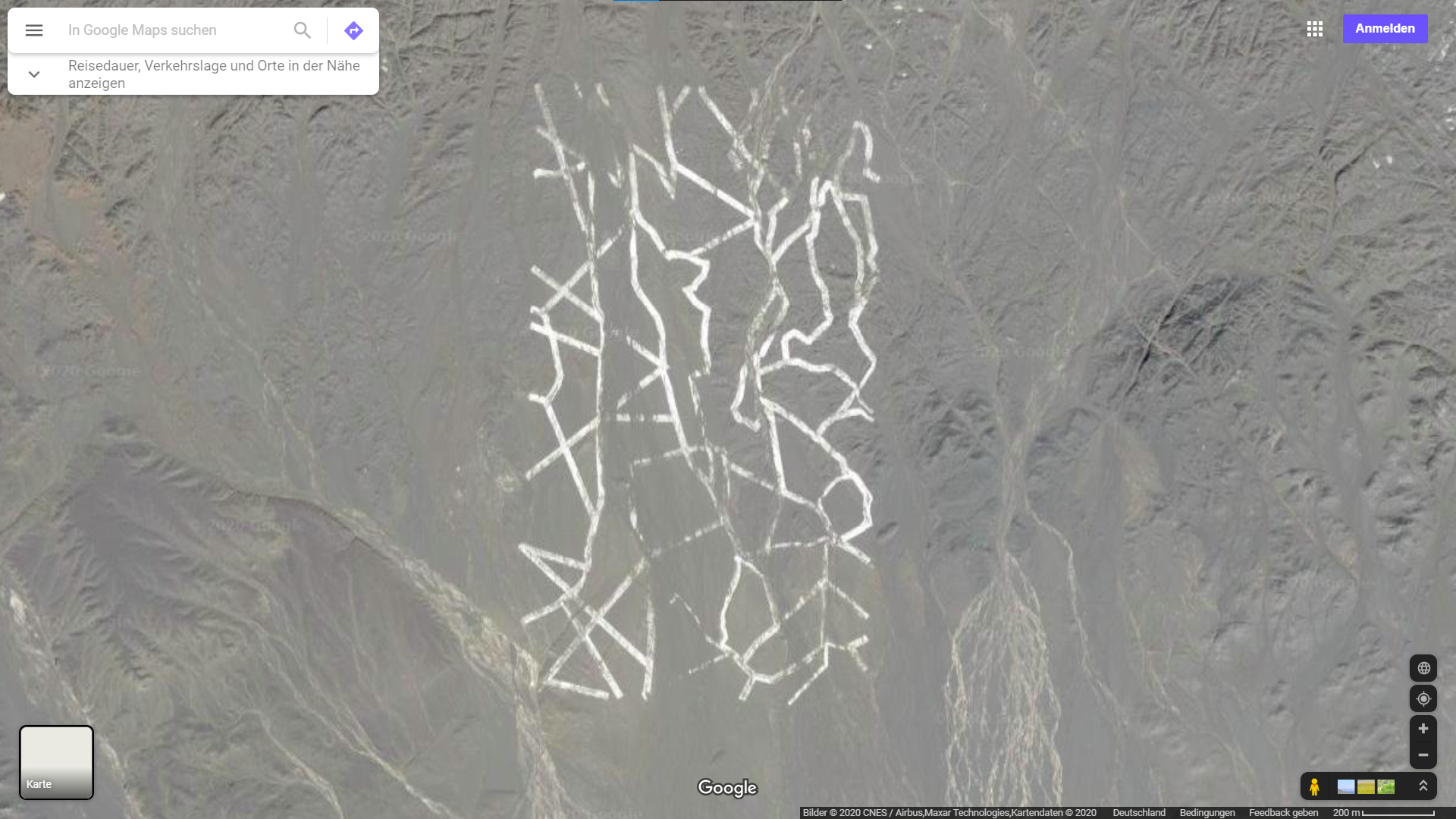
Today, the aerial and satellite images made freely available by digital map services make it possible to scan the earth’s surface for strange visual shapes, just as intelligence agencies do. For example, readers of Wired magazine made a concerted study of the Gobi Desert in 2011, where they observed a plethora of bizarre geometric structures that seemed to suggest military experiments (fig. 25). 86 Jesus Diaz, “Why Is China Building These Gigantic Structures in the Middle of the Desert?”, WIRED, 14 November 2011, http://www.wired.com/dangerroom/2011/11/china-gigantic; Noah Schachtman, “More Mammoth (and Mysterious) Structures Found in China’s Desert”, WIRED, 15 November 2011, https://www.wired.com/2011/11/mammoth-mysterious-china, and “Spy Sat Calibrators? King-Sized Jokes? China’s Colossal Structures Confound”, 16 November 2011, http://www.wired.com/dangerroom/2011/11/colossal-structures-china. But it wasn’t just China’s state secrets that Google Earth brought to the attention of the public. Back in 2007, a blogger trawling through freely accessible images spotted an American nuclear submarine whose propeller was uncovered—a technical detail that had been kept top secret for thirty years. 87 Sharon Weinberger, “Can You Spot the Chinese Nuclear Sub?”, DISCOVER Magazine, 21 July 2008, http://discovermagazine.com/2008/aug/21-can-you-spot-the-chinese-nuclear-sub.
We don’t think twice about using photographic maps to assess the location of a hotel or explore an area of a city we are not familiar with. Even inexpensive camera drones include intelligent target recognition that automatically keeps moving objects in focus during video recordings. At the same time, the drones of this kind that are regularly available in shops can be easily modified by police and government agencies to carry out surveillance tasks. What for a century appeared to be first and foremost a “weaponisation of the eye” 88Das taktische Lichtbilderbuch: Zusammengestellt aus Flugzeugaufnahmen von Ost und West; Aus der Zeit von Kriegsbeginn 1914 bis Frühjahr 1916 (n.p., 1916), 3. owing to its military use has now become an everyday aspect of our perception through the convergence of civil and military technology. 89 See, in particular, Stahl, Through the Crosshairs (see n. 15).
From Zurich to Winterthur: S 12, IC Zurich-St. Gallen and IR Zurich-Schaffhausen (20–25 min).
From Zurich Airport: IC and IR trains (15 min).
From St. Gallen: IC and IR trains (40–45 min).
From Schaffhausen: IC and IR trains (35 min).
Bus
From Winterthur train station: Bus no. 2 (direction Seen), 3 stops till “Fotozentrum”.
Car
Motorway from Zurich: exit Winterthur-Töss, direction “Zentrum” (City Centre), then follow the sign “Fotomuseum”.Motorway from St. Gallen: exit Oberwinterthur, direction “Zentrum” (City Centre), then follow the sign “Fotomuseum”.Parking facilities near the museum.